

What Does a Surveyor’s Equipment Look Like – And Why It Matters for Your Miami Property
If you’ve ever seen a surveyor working along a street, construction site, or residential property in Miami, you may have noticed tripods, poles, and electronic equipment set up around the site. Many property owners ask the same question: what exactly does a surveyor use to measure land so precisely?
Land surveying is far more than simply measuring distances. Professional surveyors use advanced technology to determine accurate property boundaries, elevations, and construction layouts. These measurements are essential for property transactions, building permits, flood compliance, and development projects throughout Miami.
Understanding the equipment surveyors use can help you see why professional surveying is so important for protecting your property and ensuring projects are completed correctly.
Essential Surveying Equipment Used in Miami
Modern land surveyors rely on several specialized tools designed for accuracy and efficiency. Here are some of the most common pieces of equipment used on Miami surveying projects.
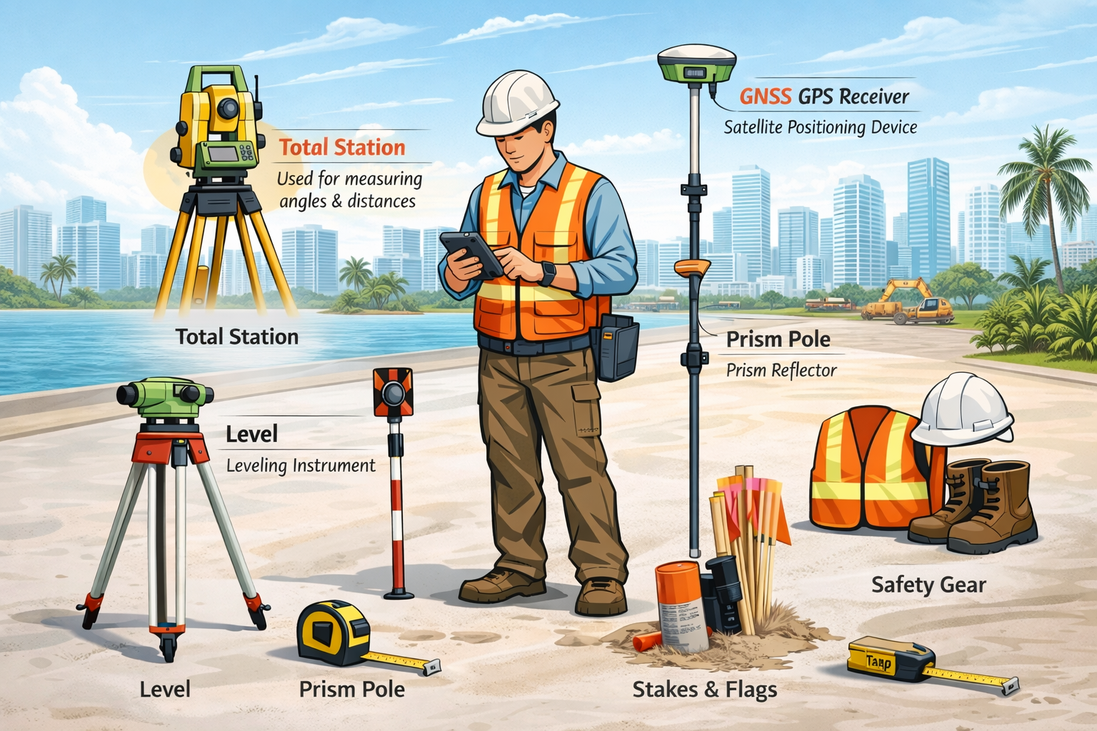
Total Station
A total station is one of the most important tools in modern surveying. It is typically mounted on a tripod and looks similar to a small telescope.
This device measures horizontal and vertical angles as well as distances, allowing surveyors to determine precise coordinates for property corners, structures, and other features.
Total stations are commonly used for:
Boundary surveys
Construction layout and stakeout
Topographic surveys
Site development projects
Because of its accuracy, the total station plays a major role in ensuring structures are built in the correct location.
GNSS / GPS Receiver
Survey-grade GNSS (Global Navigation Satellite System) receivers use satellite signals to determine precise geographic positions.
Unlike the GPS on your phone, professional surveying GPS equipment can measure positions within centimeters of accuracy.
In Miami, GNSS receivers are frequently used for:
Large property surveys
Subdivision mapping
Infrastructure and roadway projects
Establishing survey control points
These systems allow surveyors to quickly collect accurate location data across large areas.
Leveling Instrument
A leveling instrument, often called an automatic level or digital level, helps surveyors measure elevation differences between points.
Elevation data is extremely important in Miami due to:
Flood zone regulations
Drainage planning
Construction grading
Elevation certificates
Accurate elevation measurements help ensure buildings meet local requirements and reduce flooding risks.
Prism Pole / Reflector
A prism pole is a tall pole with a reflective prism mounted at the top. It works together with a total station.
The total station sends a laser beam toward the prism, which reflects the signal back to the instrument. This allows the surveyor to measure precise distances across a site.
Prism poles are commonly used when:
Measuring property corners
Locating structures
Mapping features on a property
Measuring Tape and Survey Stakes
Even with modern technology, traditional tools like measuring tapes and survey stakes are still used regularly.
Survey stakes and flags are placed in the ground to mark important points such as:
Property boundaries
Construction corners
Utility locations
Proposed building layouts
These markers help contractors and property owners visualize where work will occur.
Handheld Data Collector
A data collector is a rugged handheld device used to store measurements taken by survey equipment.
It connects directly to the total station or GPS receiver and allows surveyors to:
Record survey points digitally
Store coordinates and elevations
Create field notes and measurements
Transfer data to drafting software
This technology speeds up the process of creating accurate survey drawings and reports.
Safety Gear
Surveyors often work near roads, construction equipment, or active job sites. Because of this, safety gear is essential.
Typical safety equipment includes:
Hard hats
High-visibility reflective vests
Work boots
Protective gloves
Safety gear ensures survey crews can work safely while collecting critical data.
Why Professional Surveys Matter in Miami
Accurate surveying plays a crucial role in protecting property owners and supporting development projects across Miami.
A professional survey helps:
Prevent property boundary disputes
Knowing exactly where your property lines are can prevent legal conflicts with neighbors.
Ensure construction is built correctly
Before construction begins, surveys confirm that buildings are placed within the correct setbacks and property limits.
Meet local permit requirements
Many Miami permits require surveys, including boundary surveys, elevation certificates, and construction stakeout surveys.
Support flood zone compliance
Accurate elevation data is often required for FEMA flood zone determinations and insurance purposes.
Avoid costly mistakes
Errors in property lines or building placement can result in expensive delays or legal issues.
Get a Professional Land Survey in Miami
Whether you're buying property, planning construction, or resolving a boundary question, a professional land survey ensures everything is accurate and compliant.
Our experienced surveying team uses modern equipment and advanced technology to provide precise, reliable results for residential and commercial properties throughout Miami.
Request a Survey Today
If you need a boundary survey, elevation certificate, construction stakeout, or topographic survey in Miami, our team is ready to help.
Call today to get started or request a free quote for your property survey. Accurate surveying today can prevent costly problems tomorrow.